Weather
Flood Watch After A Month's Worth Of Rain Fell Saturday
Some areas have already received as much as four inches of rain in the past two days. A flood watch continues until 1 a.m.


The Philadelphia region is under a flood watch Monday, as another round of heavy rainfall is expected this afternoon. The area is already heavily saturated, with some communities in the suburbs getting as much as four inches of rain in the past two days, according to data from the National Weather Service.
A flood watch is in place until 1 a.m. Tuesday. The same communities that got four inches of rain Saturday are now expected to get another round of rain today. A half inch to one and one-half inches are expected, the NWS said.
Be thankful it wasn't cold enough for the precipitation to be snow on Saturday. According to experts, each inch of rain equates to 13 inches of snow. That means some areas could have received 52 inches of snow.
Find out what's happening in Newtownfor free with the latest updates from Patch.
AccuWeather confirms some communities received a month's worth of rain on Saturday night. In the Philadelphia region, the average rainfall for November is three inches all month, according to U.S. climate data.
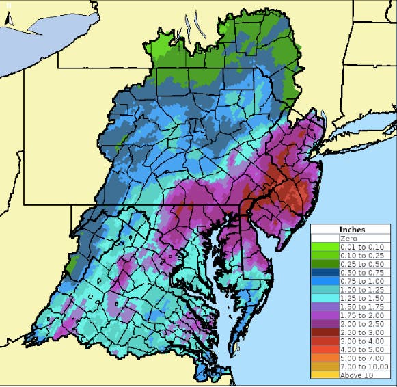
You can see the map of rainfall totals since Saturday here:
Find out what's happening in Newtownfor free with the latest updates from Patch.
Monday's additional heavy rainfall will only worsen the existing flooding threat, and could lead to more road closures up and down the I-95 corridor, AccuWeather notes. As of Monday at 11 a.m., there has been no flooding along the Delaware River, NWS maps show. You can see the levels here.
"Leaf clogged drains and coastal flooding could further exacerbate flooding issues. River flooding may continue into Wednesday or Thursday, well after the heavy rain has ended," the NWS said in its flood watch announcement.
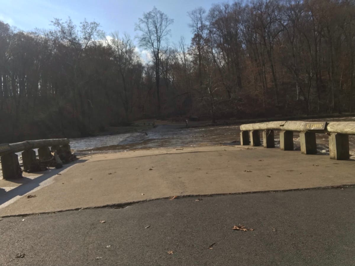
The heavy rainfall Saturday caused roads to flood, and rivers and creeks to rise. At Tyler State Park in Newtown Township, the creek flooded the pedestrian bridge.
Another round of moderate to heavy rainfall is expected today across much of the area. Here is a map showing the % of Normal Precipitation for the last 7 days. Areas of light purple and surrounding areas have the greatest threat for additional flooding, hence the Flood Watch. pic.twitter.com/o6dhBdsG8f
— NWS Mount Holly (@NWS_MountHolly) November" class="redactor-linkify-object">https://twitter.com/NWS_MountH... 26, 2018
Here is the forecast:
Today: Rain, mainly after noon. High near 52. East wind 14 to 16 mph. Chance of precipitation is 100%. New precipitation amounts between a half and three quarters of an inch possible.
Tonight: Rain before 10pm, then a slight chance of showers between 10pm and midnight. Low around 35. Light and variable wind becoming west 9 to 14 mph in the evening. Chance of precipitation is 80%. New precipitation amounts between a tenth and quarter of an inch possible.
Tuesday: Mostly sunny, with a high near 42. West wind 14 to 17 mph, with gusts as high as 29 mph.
Tuesday Night: Mostly cloudy, with a low around 27. West wind around 10 mph.
Wednesday: Mostly cloudy, with a high near 39. West wind 10 to 16 mph, with gusts as high as 28 mph.
Wednesday Night: Partly cloudy, with a low around 32.
Thursday: Sunny, with a high near 44.
Thursday Night: Partly cloudy, with a low around 31.
Friday: Partly sunny, with a high near 43.
Main photo by Erik Linden
Get more local news delivered straight to your inbox. Sign up for free Patch newsletters and alerts.