Weather
Florence Remnants Likely Headed To Pennsylvania: Here's When
Before we deliver the bad news, let us offer you the good news: THE WEEKEND WILL BE DRY!

Florence has made landfall in North Carolina as a Category 1 hurricane. It's expected to bring three inches of rain an hour to the Carolinas, and could linger there for a day, forecasters report.
But where will it go next?
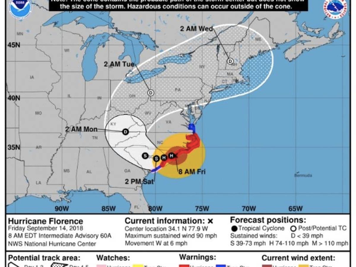
It is now likely that remnants from the storm will impact Pennsylvania, forecasters predict. An updated map of the storm's likely track was released Thursday. The storm is expected to move over Tennessee and Ohio, then onto Pennsylvania early next week, before hitting New England.
Find out what's happening in Newtownfor free with the latest updates from Patch.
"The remnants of Hurricane Florence could produce a period of heavy rain Monday into Tuesday," the NWS in State College said Friday.
Here is the map:
Find out what's happening in Newtownfor free with the latest updates from Patch.

Florence officially made landfall around 7:15 a.m. Friday near Wrightsville Beach, North Carolina.
The exact track of the storm once it leaves the will determine which locations along the coast receive the worst of Florence's damaging winds, heavy rain and storm surge flooding, according to AccuWeather. However, the weather pattern is expected to finally shift next week, allowing Florence, as a tropical rainstorm, to accelerate northeastward.
There is the potential it could leave us with 3 to 6 inches of rain.
Pennsylvania is already vulnerable to flooding, due to the high levels of rainfall we have recently received.
The good news is the weekend is looking dry.
Here is the forecast:
Today: Patchy drizzle. Cloudy, with a high near 76. East wind 9 to 11 mph.
Tonight: Patchy fog after 3am. Otherwise, mostly cloudy, with a low around 66. Northeast wind 5 to 7 mph.
Saturday: Patchy fog before 8am. Otherwise, partly sunny, with a high near 81. Northeast wind around 7 mph becoming southeast in the afternoon.
Saturday Night: Partly cloudy, with a low around 64. East wind 3 to 5 mph.
Sunday: Mostly sunny, with a high near 80. East wind 3 to 6 mph.
Sunday Night: A slight chance of showers after 2am. Partly cloudy, with a low around 66. Chance of precipitation is 20%.
Monday: A chance of showers after 8am. Partly sunny, with a high near 81. Chance of precipitation is 50%.
Monday Night: A chance of showers, then showers and thunderstorms likely after 2am. Mostly cloudy, with a low around 69. Chance of precipitation is 60%.
Tuesday: Showers and thunderstorms likely. Some of the storms could produce heavy rainfall. Mostly cloudy, with a high near 80. Chance of precipitation is 70%.
Image via National Hurricane Center
Get more local news delivered straight to your inbox. Sign up for free Patch newsletters and alerts.


