Weather
Forecasters Eyeing 2 Storms That Could Impact Eastern PA
Updates on two storms that could potentially impact Eastern PA this weekend and through next week. Lots of wet weather in the forecast.

Forecasters are offering updated information on two storms that could potentially impact Eastern Pennsylvania starting this weekend and going through next week.
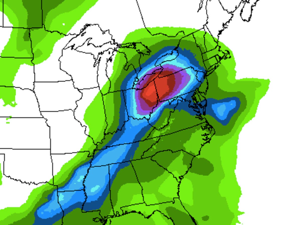
The remnants of Tropical Storm Gordon are expected to move toward the northeast this weekend, leaving rain and thunderstorms in its path. What is left of Gordon will likely pass to our west and northwest on Sunday and Monday, the National Weather Service said in its Friday forecast discussion.
But we won't have to wait for Gordon to get wet. Starting Friday, there is a chance for heavy rainfall and localized flooding. Heavy rain could continue Saturday and through the weekend; a hazardous weather outlook has been issued.
Find out what's happening in Newtownfor free with the latest updates from Patch.
In fact, despite what happens with Tropical Storm Florence (more on that below) we're looking at a chance of rain every day through late next week, the NWS predicts.
It will get cooler, however.
Find out what's happening in Newtownfor free with the latest updates from Patch.
The NWS says a secondary cold front will push south of our area on Saturday, lowering temperatures that day to a high in the lower 70s. "Temperatures will remain quite chilly on Sunday due to the rain and the cloud cover along with a northeast wind. Highs should be mainly in the middle 60s to lower 70s," the NWS said.
As we mentioned above, there is another storm shaping up that may cause additional trouble for the region.
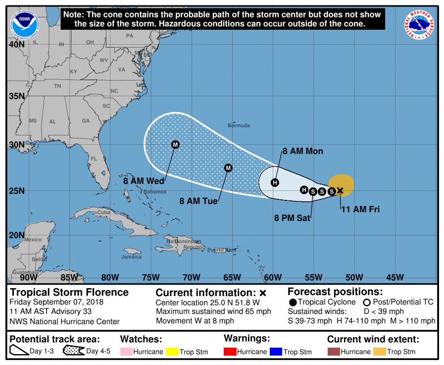
Florence, which for now has been downgraded to a tropical storm, could impact the region late next week. The National Hurricane Center said the storm is expected to strengthen over the weekend but its current tract and impacts are not yet known.
"There continues to be quite a bit of variability in the output from the forecast models. However, the broad consensus shows it affecting our region in some way late in the new week," the NWS in Mt. Holly, N.J. said.
The National Hurricane Center said Friday the risk of the East Coast experiencing a direct impact from Florence has increased. Still, it is too soon to determine the exact location, magnitude, and timing of the storm's impacts.
"Interests near and along the U.S. East Coast should monitor the progress of Florence through the weekend and ensure they have their hurricane plans in place," the National Hurricane Center said.
Forecasters will have a better idea of that storm's path and impact by early next week, the NWS said.
Here is the predicted track of Florence as of Friday morning:
Here is the forecast:
Today: A slight chance of showers, then a chance of showers and thunderstorms after noon. Cloudy, with a high near 80. Northeast wind around 6 mph. Chance of precipitation is 40%. New rainfall amounts of less than a tenth of an inch, except higher amounts possible in thunderstorms.
Tonight: A chance of showers and thunderstorms, then showers likely after midnight. Cloudy, with a low around 64. East wind 3 to 6 mph. Chance of precipitation is 60%. New precipitation amounts between a tenth and quarter of an inch, except higher amounts possible in thunderstorms.
Saturday: A chance of showers, mainly before noon. The rain could be heavy at times. Cloudy, with a high near 73. Northeast wind around 9 mph. Chance of precipitation is 50%. New precipitation amounts between a tenth and quarter of an inch possible.
Saturday Night: A chance of rain. Mostly cloudy, with a low around 60. Northeast wind 6 to 8 mph. Chance of precipitation is 50%. New precipitation amounts of less than a tenth of an inch possible.
Sunday: Rain likely, mainly after 2pm. The rain could be heavy at times. Cloudy, with a high near 68. East wind 9 to 11 mph. Chance of precipitation is 60%. New precipitation amounts between a quarter and half of an inch possible.
Sunday Night: Rain likely. The rain could be heavy at times. Cloudy, with a low around 61. Chance of precipitation is 60%. New precipitation amounts between a tenth and quarter of an inch possible.
Monday: Showers likely, with thunderstorms also possible after 2pm. Some of the storms could produce heavy rainfall. Cloudy, with a high near 78. Chance of precipitation is 60%.
Monday Night: A chance of showers and thunderstorms. Some of the storms could produce heavy rainfall. Mostly cloudy, with a low around 69. Chance of precipitation is 50%.
Tuesday: A chance of showers, with thunderstorms also possible after 2pm. Mostly cloudy, with a high near 85. Chance of precipitation is 40%.
Tuesday Night: A chance of showers and thunderstorms. Mostly cloudy, with a low around 70. Chance of precipitation is 30%.
Wednesday: A chance of showers. Partly sunny, with a high near 85. Chance of precipitation is 30%.
Wednesday Night: A chance of showers. Mostly cloudy, with a low around 69. Chance of precipitation is 30%.
Thursday: A chance of showers. Mostly cloudy, with a high near 83. Chance of precipitation is 30%.
Images via NWS
Get more local news delivered straight to your inbox. Sign up for free Patch newsletters and alerts.


