Weather
Friday Storms Likely Start To Cooler, Wet Weekend In PA
Severe thunderstorms could rattle the Philadelphia region this weekend, beginning on Friday evening.


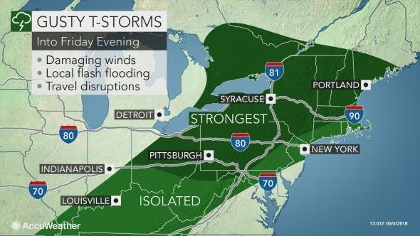
Severe thunderstorms could rattle the Philadelphia region this weekend, beginning on Friday evening. The National Weather Service has issued a hazardous weather outlook for some of Eastern Pennsylvania, saying there is a chance for severe thunderstorms Friday evening and into the night.
AccuWeather is warning of damaging thunderstorms and gusty winds across the region. Meteorologists with that network say the system will "speed through the Northeast" on Friday evening.
The storms will bring some cooler air to the region, and could also result in high winds, forecasters predict. Damage to trees and power lines is possible, as well as hail, according to AccuWeather.
Find out what's happening in Newtownfor free with the latest updates from Patch.
According to the NWS, the northeast should brace for storms that will be followed by a cold front. On Friday, temperatures across the area are as much as 25 degreeshigher than average. By Saturday, due to the cold front, temperatures will be closer to average for early May, the NWS said.
Here is the National Weather Service's map showing where a hazardous weather outlook is currently in place:
Find out what's happening in Newtownfor free with the latest updates from Patch.

The risk of flash flooding will be limited to a localized level given the quick-moving nature of the overall storm system. “The severity of the thunderstorms is expected to lessen prior to reaching the I-95 corridor,” AccuWeather Senior Meteorologist Kristina Pydynowski said in a news release.
Here is the forecast:
Today: Mostly cloudy, with a high near 89. Light southwest wind increasing to 9 to 14 mph in the afternoon. Winds could gust as high as 26 mph.
Tonight: A chance of showers and thunderstorms before 10pm, then a slight chance of showers between 10pm and midnight. Mostly cloudy, with a low around 59. West wind 10 to 14 mph, with gusts as high as 25 mph. Chance of precipitation is 30%. New precipitation amounts of less than a tenth of an inch, except higher amounts possible in thunderstorms.
Saturday: A chance of showers, mainly after 2pm. Mostly cloudy, with a high near 73. Northwest wind around 6 mph. Chance of precipitation is 30%. New precipitation amounts of less than a tenth of an inch possible.
Saturday Night: A chance of showers. Cloudy, with a low around 55. Southwest wind 5 to 7 mph becoming calm after midnight. Chance of precipitation is 50%. New precipitation amounts between a tenth and quarter of an inch possible.
Sunday: Showers likely. Cloudy, with a high near 68. Northeast wind around 6 mph. Chance of precipitation is 60%. New precipitation amounts between a tenth and quarter of an inch possible.
Sunday Night: A chance of showers, mainly before 2am. Mostly cloudy, with a low around 51. Chance of precipitation is 30%. New precipitation amounts of less than a tenth of an inch possible.
Monday: Mostly sunny, with a high near 66.
Photo via Shutterstock
Get more local news delivered straight to your inbox. Sign up for free Patch newsletters and alerts.


