Weather
Hazardous Weather Outlook Issued Ahead Of 102 Heat Index In PA
The first day of school for many area students will be a very, very hot one with heat index values up to 102 degrees, forecasters say.


It's going to be a mostly sunny and hot day for the unofficial last day of summer, and the heat will only get more intense as the week progresses.
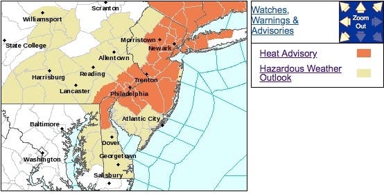
The National Weather Service has issued a hazardous weather outlook as the heat index is supposed to top 102 degrees on Tuesday. A heat advisory has been issued for Eastern Pennsylvania from 11 a.m. to 6 p.m. on Tuesday, which is the first day of school for many area students.
Heat index values near 100 degrees are possible again on Wednesday and Thursday, the NWS said. "The heat advisory may need to be extended as we get closer," the National Weather Service said in its hazardous weather outlook statement.
Find out what's happening in Newtownfor free with the latest updates from Patch.
Here are the alerted areas:
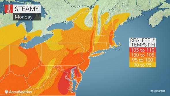
Much of the first week of September will feel like the middle of July in the eastern and central United States as temperatures soar and high humidity levels hold on, according to AccuWeather. A large high pressure system, known as the Bermuda High, will hold firm over the East this week.
Find out what's happening in Newtownfor free with the latest updates from Patch.
Unlike the setup that brought high humidity and frequent torrential downpours to much of the region during July and August, many areas from the Ohio Valley to the Carolinas, mid-Atlantic and New England coasts will be free of rain most of the time this week with some exceptions, according to AccuWeather.
"Areas at highest risk of experiencing a spotty afternoon thunderstorm on Labor Day are across the central Appalachians," AccuWeather Senior Meteorologist Kristina Pydynowski said in an AccuWeather release. "Thunderstorms will also push into northern New England."
Here is the forecast:
Monday: Mostly sunny, with a high near 91. Calm wind becoming west around 5 mph.
Monday night: Patchy fog after 10pm. Otherwise, partly cloudy, with a low around 72. Southwest wind 3 to 5 mph.
Tuesday: Mostly sunny, with a high near 93. Heat index values as high as 101. Light northwest wind.
Tuesday Night: Partly cloudy, with a low around 73. Light northwest wind.
Wednesday: Mostly sunny, with a high near 93. Light northeast wind.
Wednesday Night: Partly cloudy, with a low around 73.
Thursday: A chance of showers and thunderstorms after 2pm. Mostly sunny, with a high near 91. Chance of precipitation is 30%.
Thursday Night: A chance of showers and thunderstorms. Mostly cloudy, with a low around 71. Chance of precipitation is 40%.
Friday: Showers and thunderstorms likely. Mostly cloudy, with a high near 81. Chance of precipitation is 60%.
Image via Shutterstock
Get more local news delivered straight to your inbox. Sign up for free Patch newsletters and alerts.


