Weather
PA Weather: Hazardous Weather Outlook Issued Ahead Of Stormy Tuesday
Tuesday is going to be stormy and wet, the National Weather Service predicts.


The abundant sunshine that graced us for the past several days is on its way out, and Eastern Pennsylvania is about to be hit with some of the roughest weather we've had in a month. The National Weather Service has issued a Hazardous Weather Outlook for the Philadelphia region due to heavy rainfall that is likely Tuesday morning and afternoon.
The Hazardous Weather Outlook is in place in Bucks, Chester, Delaware, Montgomery and Philadelphia counties, as well as in the Lehigh Valley.
The storms may cause localized flooding of roadways and areas of poor drainage, forecasters predict.
Find out what's happening in Newtownfor free with the latest updates from Patch.
Scattered strong thunderstorms are expected, and pockets of damaging wind are possible Tuesday, especially during the afternoon, according to the National Weather Service.
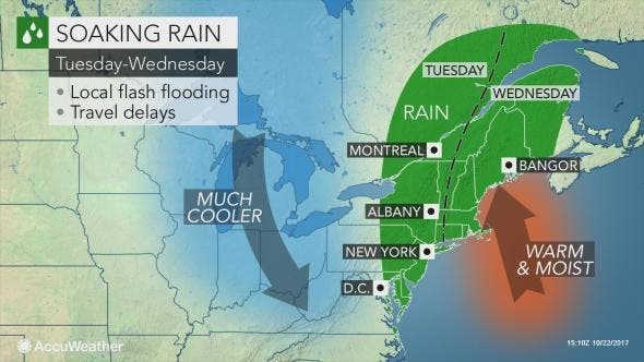
The change in the weather pattern will bring the return of rain and cool air to the northeastern United States this week, while elevating the risk for travel disruptions, according to AccuWeather.
Find out what's happening in Newtownfor free with the latest updates from Patch.
“Across much of this region, it has been dry recently, which should mean that the ground can absorb most of the rainfall,” AccuWeather Lead Long-Range Meteorologist Paul Pastelok said in a news release. The pace of the storm should limit the period of heaviest rain and the flood threat to a localized level.
“[However], watch for street flooding,” Pastelok said.
Here is the forecast:
Today: Mostly cloudy, with a high near 72. South wind 6 to 9 mph.
Tonight: Showers, with thunderstorms also possible after 5am. Low around 64. Southeast wind around 9 mph. Chance of precipitation is 90%. New rainfall amounts between a tenth and quarter of an inch, except higher amounts possible in thunderstorms.
Tuesday: Showers and possibly a thunderstorm. Some of the storms could produce gusty winds and heavy rain. High near 75. South wind 10 to 13 mph, with gusts as high as 29 mph. Chance of precipitation is 100%. New rainfall amounts between 1 and 2 inches possible.
Tuesday Night: Showers, mainly before midnight. Low around 56. South wind 5 to 9 mph becoming light southwest after midnight. Chance of precipitation is 90%. New precipitation amounts between three quarters and one inch possible.
Wednesday: Partly sunny, with a high near 68. West wind 5 to 9 mph.
Wednesday Night: A chance of showers after 4am. Mostly cloudy, with a low around 43. Chance of precipitation is 30%. New precipitation amounts of less than a tenth of an inch possible.
Thursday: A chance of showers before 8am. Mostly sunny, with a high near 61. Chance of precipitation is 30%.
Thursday Night: Mostly clear, with a low around 40.
Friday: Sunny, with a high near 66.
Friday Night: Mostly clear, with a low around 44.
Patch file photo
Get more local news delivered straight to your inbox. Sign up for free Patch newsletters and alerts.