Weather
Hurricane Florence And Pennsylvania: Will We Be Impacted?
The National Weather Service has issued a Hazardous Weather Outlook in Eastern Pennsylvania, where Florence could still have impacts.


Hurricane Florence is expected to become a major hurricane this week, and the National Hurricane Center is warning all residents in the Mid-Atlantic to closely monitor the forecast. While the current path is projected to be a direct hit on the Carolinas, the National Weather Service has issued a Hazardous Weather Outlook in Eastern Pennsylvania, where the storm could still have impacts.
"Impacts from Hurricane Florence are possible later this week," the National Weather Service said in its Hazardous Weather Outlook. "Continue to monitor the latest forecasts from the National Hurricane Center and begin to think of preparations in case Florence has an impact on the region."
The storm, which was a Category 3 with 115 mph winds at 11:30 a.m., has already been upgraded to a Category 4.
Find out what's happening in Newtownfor free with the latest updates from Patch.
If the hurricane follows the predicted course, it will have the most impact on the Carolinas. However, the Philadelphia region could still get residual winds and rains, the NWS said.
Stay on top of Hurricane Florence news and info. Get free Patch email alerts. Find your Patch town and subscribe.
Find out what's happening in Newtownfor free with the latest updates from Patch.
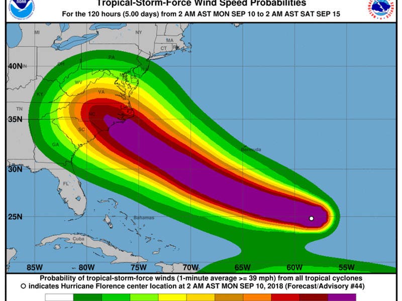
Here is a map of forecasted wind speeds:
"It is not out of the realm of possibility that Florence becomes a Category 5 hurricane before it nears the Eastern Seaboard," according to AccuWeather forecasters.
If Florence comes ashore as a Category 4 hurricane, damaging winds and power outages may extend inland more than 100 miles, Accuweather said. "Strong high pressure to the north may also enhance winds farther north along the coast than what would normally occur," said AccuWeather Senior Meteorologist Alex Sosnowski.
"As a result, people from southeastern Virginia to southern New Jersey could have damaging winds and significant coastal flooding, even if Florence hovers or moves ashore in North Carolina."
However, the storm track and speed is still fluctuating.
In the meantime, we have some more wet weather ahead. A flash flood watch has been extended through Tuesday, and there is a chance of rain each day through Friday.
Here is the forecast:
Today: Showers, with thunderstorms also possible after 3pm. High near 71. East wind around 10 mph. Chance of precipitation is 80%. New rainfall amounts between a tenth and quarter of an inch, except higher amounts possible in thunderstorms.
Tonight: Showers likely and possibly a thunderstorm before 11pm, then a chance of showers and thunderstorms between 11pm and 1am, then showers likely and possibly a thunderstorm after 1am. Cloudy, with a low around 70. East wind 5 to 7 mph becoming light and variable after midnight. Chance of precipitation is 60%. New rainfall amounts between a tenth and quarter of an inch, except higher amounts possible in thunderstorms.
Tuesday: A chance of showers, then showers and thunderstorms likely after 2pm. Mostly cloudy, with a high near 83. Light and variable wind. Chance of precipitation is 60%. New rainfall amounts of less than a tenth of an inch, except higher amounts possible in thunderstorms.
Tuesday Night: A chance of showers and thunderstorms. Mostly cloudy, with a low around 68. Calm wind. Chance of precipitation is 40%. New rainfall amounts of less than a tenth of an inch, except higher amounts possible in thunderstorms.
Wednesday: A chance of showers and thunderstorms. Mostly cloudy, with a high near 83. Light northeast wind. Chance of precipitation is 50%. New rainfall amounts of less than a tenth of an inch, except higher amounts possible in thunderstorms.
Wednesday Night: A chance of showers and thunderstorms. Mostly cloudy, with a low around 70. Chance of precipitation is 30%. New rainfall amounts of less than a tenth of an inch, except higher amounts possible in thunderstorms.
Thursday: A chance of showers, with thunderstorms also possible after 8am. Mostly cloudy, with a high near 83. Chance of precipitation is 40%.
Thursday Night: A chance of showers and thunderstorms. Mostly cloudy, with a low around 70. Chance of precipitation is 30%.
Friday: A chance of showers, with thunderstorms also possible after 8am. Mostly cloudy, with a high near 80. Chance of precipitation is 40%.
Image via National Hurricane Center
Get more local news delivered straight to your inbox. Sign up for free Patch newsletters and alerts.


