Weather
Accumulation Estimates Released For Possible Wednesday Snow
The next dose of winter weather could come Wednesday, according to the National Weather Service. Accumulation estimates have been released.

Snow is in the forecast for Eastern Pennsylvania this week, as the recovery from Friday's vicious nor'easter continues. More than 67,000 PECO customers remain without power as of Sunday night.
The next dose of winter weather could come Wednesday, according to the National Weather Service.
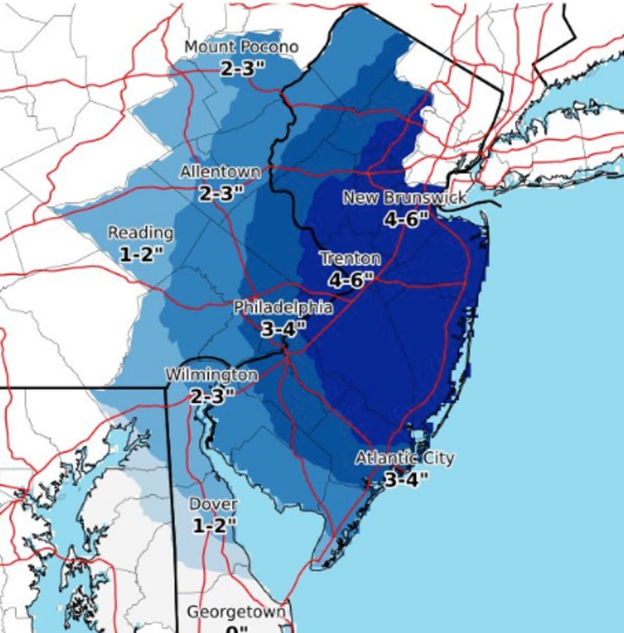
The NWS is predicting between 4 to 6 inches of snow in areas just east of Philadelphia, and 3 to 4 inches in the city and nearby.
Find out what's happening in Newtownfor free with the latest updates from Patch.
Here is a map:
NJ DE Atlc cstl flooding, high tide tngt. prob Mon & Mon night high tides. Nor'easter Wed-Wed eve should be a high impact stm for ptns e PA and NJ. Still uncertainty, but 6" psbl, axis unknown, probably vcnty I-78 nwd. Pwr outages psbl. Rain psbl coast. #njwx #dewx #pawx #mdwx pic.twitter.com/OQjJxWdnCQ
— NWS Mount Holly (@NWS_MountHolly) March 4, 2018
Meanwhile, the region is still recovering from Friday's storm, which caused nearly a half a million power outages in Eastern Pennsylvania. In Delaware County, more than 11 percent of PECO customers have no power as of Sunday night. Outages also include 26,000 in Montgomery County and 6,000 in Bucks County.
Find out what's happening in Newtownfor free with the latest updates from Patch.
The storm dumped as much as two feet of snow in parts of the Poconos. Some parts of suburban Philadelphia got significant accumulation despite the original forecasts indicating it was a rain event. See the town-by-town snowfall totals for Eastern Pennsylvania.
Here is the current forecast:
Today: Mostly cloudy, then gradually becoming sunny, with a high near 46. North wind 10 to 16 mph, with gusts as high as 30 mph.
Tonight: Mostly clear, with a low around 28. North wind around 14 mph.
Monday: Mostly sunny, with a high near 46. North wind 9 to 14 mph.
Monday night: Partly cloudy, with a low around 28. North wind 5 to 7 mph becoming calm after midnight.
Tuesday: Partly sunny, with a high near 45. Calm wind becoming southeast around 5 mph in the afternoon.
Tuesday night: Rain likely before 8pm, then rain and snow likely between 8pm and 1am, then snow likely after 1am. Cloudy, with a low around 33. Southeast wind around 6 mph. Chance of precipitation is 70%. New snow accumulation of around an inch possible
Wednesday: Snow. High near 37. Chance of precipitation is 80%.
Wednesday night: Chance of snow before 1am, then a chance of snow showers after 1am. Mostly cloudy, with a low around 29. Chance of precipitation is 40%.
Thursday: Partly sunny, with a high near 41.
NWS accumulation estimate map
Get more local news delivered straight to your inbox. Sign up for free Patch newsletters and alerts.