Weather
Prepare For Heavy Downpours, 4 Inches Of Rain In Eastern PA: NWS
You can expect as much as four inches of rain today. A flash flood watch begins at 2 p.m.


A Flash Flood Watch has been issued for Southeastern Pennsylvania ahead of what is expected to be a very wet, stormy day. The National Weather Service has issued the watch across the Philadelphia region, including in Bucks, Chester, Delaware, Montgomery and Philadelphia counties.
The Flash Flood Watch starts at 2 p.m. and goes through early Friday morning. Areas along and southeast of the Interstate 95 corridor should expect as much as four inches of rain, the NWS warns.
The storms and winds are a result of moisture from Tropical Storm Michael as it heads northeast. The actual storm isn't expected to hit the Philadelphia region or the New Jersey coast, but the area will get plenty of moisture produced by the weather system that slammed into the Florida panhandle on Wednesday with 155-mph winds.
Find out what's happening in Newtownfor free with the latest updates from Patch.
As of mid-morning, showers had already begun in some parts of the Philadelphia region. The heaviest rainfall is expected during the afternoon and late at night.
"Flash flooding is possible on roadways and especially in areas of poor drainage. Minor flooding along small streams and creeks is possible as well," the NWS said in its watch notice.
Find out what's happening in Newtownfor free with the latest updates from Patch.
Forecasters warn that people in locations prone to flooding should monitor the forecast. "Be prepared to take action" if the flash flood watch turns into a warning, the NWS said.
Some unsettled weather will linger through Saturday. But Sunday looks to be perfect apple picking or pumpkin patching weather. The forecast that day calls for mostly sunny, skies with nice seasonal high temperature around 60.
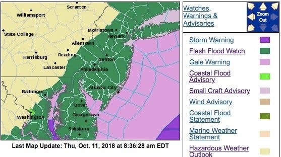
Here is a map of the alerted areas:
Here is the forecast:
Today: Showers and possibly a thunderstorm. Some of the storms could produce heavy rain. High near 79. Southwest wind around 7 mph, with gusts as high as 21 mph. Chance of precipitation is 100%. New rainfall amounts between a half and three quarters of an inch possible.
Tonight: Showers and possibly a thunderstorm before 1am, then showers likely. Some of the storms could produce heavy rain. Patchy fog before 3am. Low around 56. Calm wind becoming north around 6 mph after midnight. Chance of precipitation is 90%. New rainfall amounts between a half and three quarters of an inch possible.
Friday: A chance of showers, mainly before 8am. Mostly sunny, with a high near 63. Northwest wind 13 to 15 mph. Chance of precipitation is 30%. New precipitation amounts of less than a tenth of an inch possible.
Friday Night: Partly cloudy, with a low around 46. Northwest wind 5 to 8 mph.
Saturday: A chance of showers after 9am. Partly sunny, with a high near 58. Northwest wind 6 to 9 mph. Chance of precipitation is 30%.
Saturday Night: A chance of showers before 9pm. Mostly clear, with a low around 43. Chance of precipitation is 30%.
Sunday: Mostly sunny, with a high near 60.
Sunday Night: Mostly cloudy, with a low around 50.
Image via Shutterstock
Get more local news delivered straight to your inbox. Sign up for free Patch newsletters and alerts.


