Weather
Rain From Hurricane Nate Could Drench Pennsylvania Early Next Week: Forecasters
Nate's winds will weaken but it is expected to bring drenching rain to parts of the Northeast early next week, according to forecasters.

Hurricane Nate, which is projected to make landfall along the Gulf Coast Saturday night, is expected to weaken as it moves inland, but it still could could impact Pennsylvania with significant rain early next week.
Nate has pounded parts of Central America with tremendous rainfall, causing flooding and mudslides in Costa Rica, Nicaragua and Honduras, where — in addition to the 22 fatalities — many people are missing.
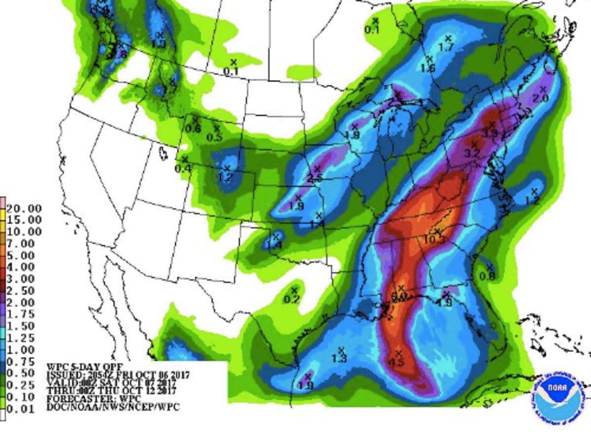
Early in the week, Nate's winds will weaken but it is expected to bring drenching rain to parts of the Northeast on Monday and Tuesday, according to forecasters. As much as three inches of rain could fall, AccuWeather predicts.
Find out what's happening in Newtownfor free with the latest updates from Patch.
The Weather Channel expects 100 million people from across the Gulf Coast to the Tennessee Valley and the Northeast will get an inch or more of rain as a result of Nate. As long as the storm does not stall in one location for several hours, however, flash flooding should be limited.
The rain comes at a good time, forecasters with AccuWeather note; parts of Pennsylvania have experienced abnormally dry conditions since late August and early September.
Find out what's happening in Newtownfor free with the latest updates from Patch.
You can see the forecast path of heavy rainfall into our region associated with Tropical Storm #Nate. Rainfall forecast over next 5 days. pic.twitter.com/nWYRfsiExZ
— Gary Szatkowski (@GarySzatkowski) October 6, 2017
Here is the forecast:
Today: Partly sunny, with a high near 86. Light southeast wind becoming south 9 to 14 mph in the morning.
Tonight: A chance of showers, mainly after 2am. Mostly cloudy, with a low around 68. South wind around 8 mph. Chance of precipitation is 30%. New precipitation amounts of less than a tenth of an inch possible.
Sunday: Showers likely, with thunderstorms also possible after 2pm. Cloudy, with a high near 79. Southwest wind around 10 mph. Chance of precipitation is 60%. New rainfall amounts between a tenth and quarter of an inch, except higher amounts possible in thunderstorms.
Sunday Night: A chance of showers and thunderstorms, then showers likely after 8pm. Cloudy, with a low around 68. Southwest wind around 7 mph. Chance of precipitation is 70%. New precipitation amounts between a quarter and half of an inch possible.
Monday: Showers and possibly a thunderstorm. High near 78. South wind around 10 mph. Chance of precipitation is 80%. New rainfall amounts between a half and three quarters of an inch possible.
Monday Night: Showers likely. Mostly cloudy, with a low around 66. Chance of precipitation is 60%. New precipitation amounts between a half and three quarters of an inch possible.
Tuesday: A chance of showers. Partly sunny, with a high near 79. Chance of precipitation is 30%.
Tuesday Night: Mostly cloudy, with a low around 59.
Wednesday: A chance of showers. Partly sunny, with a high near 71. Chance of precipitation is 30%.
Wednesday Night: A chance of showers. Partly cloudy, with a low around 52. Chance of precipitation is 30%.
PHOTO: National Weather Service
Get more local news delivered straight to your inbox. Sign up for free Patch newsletters and alerts.