Weather
Snow In Next Week's Forecast For Eastern Pennsylvania
You might need that snow shovel again next week.


There are two chances for snow in next week's forecast for Eastern Pennsylvania, according to forecasters. The National Weather Service is forecasting snow could make a return to the Philadelphia region on Monday night and Tuesday morning. Another storm could make its way to the region by Groundhog Day, which is Friday, Feb. 2, AccuWeather is predicting.
Snow and slippery travel could be a factor for the Tuesday morning commute.
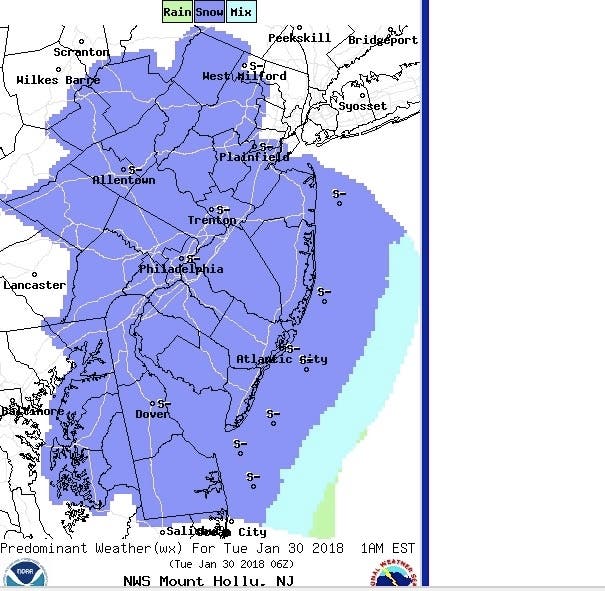
Here is the NWS forecast for 7 a.m. on Tuesday:
Find out what's happening in Newtownfor free with the latest updates from Patch.
While temperatures are expected to reach the 50s on Saturday and Sunday, a southern storm is expected to turn northward. Just enough cold air may arrive to produce snow showers on Monday night and Tuesday morning in New Jersey, according to AccuWeather.
"How quickly these three components come together will determine the extent of dry air and flurries versus accumulating snow," AccuWeather Lead Long-Range Meteorologist Paul Pastelok said in a news release.
Find out what's happening in Newtownfor free with the latest updates from Patch.
The winter weather may not end there.
Following another surge of warm air during the middle part of next week, rain is expected late in the week, AccuWeather Senior Meteorologist Brett Anderson said in a news release. Depending on temperatures and the storm track, that rain could become snow in Eastern Pennsylvania, AccuWeather says.
More on that as it gets closer.
Here is the current forecast:
Today: Sunny, with a high near 41. Calm wind becoming south around 6 mph in the afternoon.
Tonight: Mostly clear, with a low around 27. South wind around 5 mph becoming calm in the evening.
Saturday: Mostly sunny, with a high near 55. Southwest wind 7 to 14 mph, with gusts as high as 24 mph.
Saturday Night: Rain likely, mainly after 1am. Cloudy, with a low around 45. Southwest wind 8 to 11 mph. Chance of precipitation is 70%. New precipitation amounts between a tenth and quarter of an inch possible.
Sunday: A chance of rain. Mostly cloudy, with a high near 54. West wind around 6 mph becoming calm in the afternoon. Chance of precipitation is 50%. New precipitation amounts of less than a tenth of an inch possible.
Sunday Night: A slight chance of rain. Mostly cloudy, with a low around 35. Chance of precipitation is 20%.
Monday: Partly sunny, with a high near 45.
Monday Night: A chance of snow after 1am. Mostly cloudy, with a low around 26. Chance of precipitation is 30%.
Tuesday: A chance of snow before 1pm. Partly sunny, with a high near 33. Chance of precipitation is 30%.
Tuesday Night: Mostly clear, with a low around 16.
PHOTO: NWS
Get more local news delivered straight to your inbox. Sign up for free Patch newsletters and alerts.