Weather
Severe Storms Wednesday, Snow Friday In Pennsylvania
"Damaging" storms and snow are in this week's forecast as the new month begins.

Pennsylvania should prepare itself for a stormy week. And the worst of it won't be the snow predicted for Friday morning. A potentially "damaging" storm system - including possible tornadoes - could hit Pennsylvania on Wednesday.
That system could be followed by what may be the last chance for snow this winter, with temperatures expected to momentarily drop. The National Weather Service has issued a hazardous weather alert for the storm system that's supposed to hit the region on Wednesday.
As for the snow: there's a chance of snow showers before 8 a.m. Friday, then a chance of rain and snow showers mid-morning Friday. Precipitation should turn to all rain after 10 a.m. New snow accumulation of less than a half inch is possible.
Find out what's happening in Newtownfor free with the latest updates from Patch.
Here is what's expected Wednesday, according to the National Weather Service:
- Severe Thunderstorms: The biggest threats will be damaging wind gusts in excess of 60 mph, deadly and damaging cloud-to-ground lightning, and poor drainage flooding.
- Large hail bigger than 1 inch in diameter and isolated tornadoes are also possible.
- Isolated thunderstorms may develop late Wednesday morning through early afternoon (roughly 9 a.m. to 1 p.m.).
- The primary threat from these storms will be small hail and heavy rain. There is a potential for one or two organized lines of strong to severe thunderstorms to move through the region late Wednesday afternoon (3 to 6 p.m.) and/or Wednesday evening (6 to 11 p.m.).
- Damaging winds, deadly and damaging lightning and heavy rain are possible.
- Storms will produce heavy rain, and there may be localized flooding in areas of poor drainage.
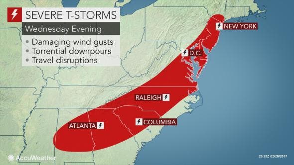
Here's AccuWeather's map of the storm:
Find out what's happening in Newtownfor free with the latest updates from Patch.
Some of those storms have already hit the Midwest and have left some damage, according to AccuWeather.

The latest surge of warm air will trigger another round of severe thunderstorms in parts of the eastern United States Wednesday and Wednesday night, according to AccuWeather.
The eastern storms will be a continuation of a deadly severe weather outbreak over parts of the Midwest on Tuesday night. The storms will continue to pose a risk to lives and property. Airline delays will mount. The commute on area highways will be slowed, according to AccuWeather.
Strong winds aloft will allow the storms to pack a powerful punch. As the storms reach high into the atmosphere, the strong winds from aloft will be carried down to the surface.
Multiple showers and thunderstorms with travel delays will affect areas from Boston, New York City, Philadelphia, Baltimore and Washington, D.C. into Wednesday evening. While some of these storms can be heavy and gusty, the risk of widespread damaging storms may hold off until later in the day, according to AccuWeather.
The greatest chance of severe thunderstorms from New York City to Philadelphia will be during Wednesday afternoon. Areas from Baltimore and Washington, D.C., to Charlotte, North Carolina, and Atlanta will be during late Wednesday afternoon and evening, according to AccuWeather.
Rounds of downpours with thunder and lightning, as well as locally gusty winds will occur from northern Pennsylvania and upstate New York through New England into Wednesday evening. Widespread severe weather is unlikely in this area, according to AccuWeather.
Here is AccuWeather's prediction for the entire month:
Photos: AccuWeather
Get more local news delivered straight to your inbox. Sign up for free Patch newsletters and alerts.