Weather
Snowfall Predictions Released For Next PA Nor'easter
Snowfall predictions for Nor'easter four have been released. And bad news: Another snowstorm could follow immediately after, NWS says.


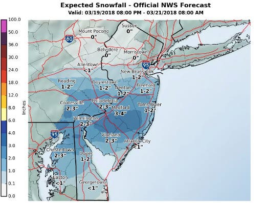
Forecasters with the National Weather Service have released snowfall predictions for a storm expected to impact the area from late Monday night into Tuesday. According to predictions made by that agency, the Philadelphia area could see up to three inches of snow.
Forecasters say they're watching another storm that could follow in the middle of the week. That storm also has the potential for heavy, wet snow. (More on that below)
But first, the National Weather Service says the early week coastal storm will bring wintry mix and could make for a slippery Tuesday morning commute. "Rain and perhaps sleet mixing in with the wet snow could cut down on snowfall accumulations, especially south of the Mason-Dixon line," the NWS said. "A sharp cutoff in the snowfall is expected near or just north of Philadelphia.
Find out what's happening in Newtownfor free with the latest updates from Patch.
Another coastal storm could follow Tuesday night into Wednesday night, "though confidence in a direct impact from this second system is low. If the storm tracks close enough to the area, heavy, wet snow and strong northeast winds would be possible during this time."
Here is the snowfall map for the Monday/Tuesday storm:
Find out what's happening in Newtownfor free with the latest updates from Patch.
Here is the forecast:
Tonight: Mostly clear, with a low around 29. Northwest wind 5 to 9 mph becoming calm in the evening.
Monday: Sunny, with a high near 47. North wind around 7 mph.
Monday Night: A chance of snow, mainly after 4am. Mostly cloudy, with a low around 30. Northeast wind 3 to 6 mph. Chance of precipitation is 30%. New snow accumulation of less than a half inch possible.
Tuesday: Snow likely, mainly between 7am and 2pm. Mostly cloudy, with a high near 38. Northeast wind 11 to 13 mph, with gusts as high as 24 mph. Chance of precipitation is 60%. New snow accumulation of 1 to 2 inches possible.
Tuesday Night: A chance of snow, mainly before 8pm. Mostly cloudy, with a low around 29. Northeast wind 8 to 11 mph. Chance of precipitation is 30%. New snow accumulation of less than a half inch possible.
Wednesday: A chance of snow before noon, then a chance of rain and snow. Mostly cloudy, with a high near 39. Chance of precipitation is 40%. New precipitation amounts of less than a tenth of an inch possible.
Wednesday Night: A chance of snow before 11pm. Mostly cloudy, with a low around 29. Chance of precipitation is 30
Thursday: Partly sunny, with a high near 44.
Thursday Night: Mostly cloudy, with a low around 30.
Image via NWS
Get more local news delivered straight to your inbox. Sign up for free Patch newsletters and alerts.


