Weather
Timing, Latest Forecast For Severe Storms Tuesday In Eastern PA
Thunderstorms with torrential rainfall and high winds are expected throughout the Philadelphia region Tuesday. Here's what you need to know:

EASTERN PENNSYLVANIA —Thunderstorms with torrential rainfall and high winds are expected throughout the Philadelphia region Tuesday. A Flash Flood Watch is in place throughout the area, including in Southeastern Pennsylvania and parts of New Jersey.
While the Flash Flood Watch starts at 2 p.m., the worst of the storms are expected to start a bit later in the afternoon. The storms will last through the evening and could linger into the the night, forecasters say.
According to the National Weather Service, showers and thunderstorms will begin to develop around midday and continue through the afternoon and evening hours. Periods of heavy rain can be expected with areas of one to two inches, with local amounts up to three inches possible.
Find out what's happening in Newtownfor free with the latest updates from Patch.
In addition to the heavy downpours, the storms could bring winds up to 30 to 60-mph. "Hail and an isolated tornado cannot be ruled out," the NWS said.
The same storm system was responsible for triggering severe weather across the Midwest Monday.
Find out what's happening in Newtownfor free with the latest updates from Patch.
"Thunderstorms that form in the area at risk can produce wind gusts high enough to down trees and power lines, hail, flooding downpours and even an isolated tornado," AccuWeather Meteorologist Renee Duff said in a news release.
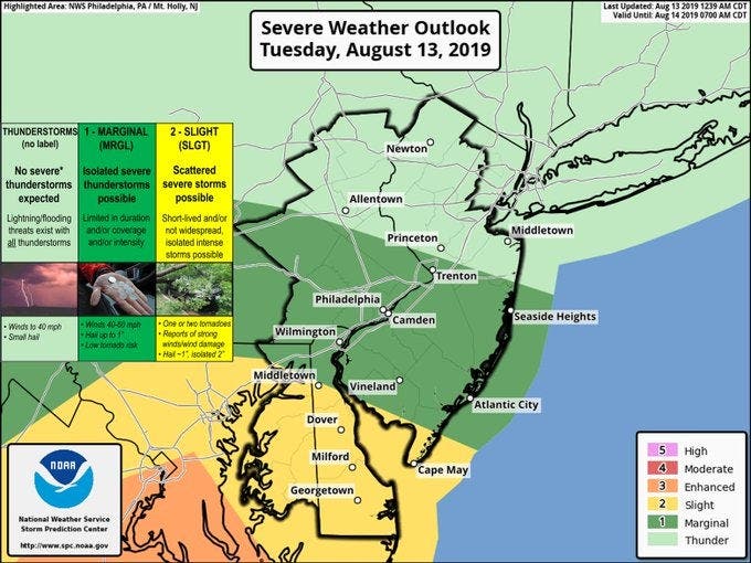
Here is a map of the areas impacted by today's severe weather outlook:
(Story continues below)
Here is the current local forecast:
Today: Showers and thunderstorms after noon. Some of the storms could produce gusty winds and heavy rain. High near 84. Southwest wind 5 to 8 mph. Chance of precipitation is 80%. New rainfall amounts between a quarter and half of an inch possible.
Tonight: Showers and thunderstorms likely before 5am, then a chance of showers. Some of the storms could produce heavy rainfall. Mostly cloudy, with a low around 71. Light west wind. Chance of precipitation is 60%. New rainfall amounts between a quarter and half of an inch possible.
Wednesday: A slight chance of showers, then a chance of showers and thunderstorms after 11am. Mostly cloudy, with a high near 83. North wind 6 to 8 mph. Chance of precipitation is 40%. New rainfall amounts of less than a tenth of an inch, except higher amounts possible in thunderstorms.
Wednesday Night: A chance of showers and thunderstorms before 2am, then a slight chance of showers. Mostly cloudy, with a low around 68. Light northeast wind. Chance of precipitation is 30%. New rainfall amounts of less than a tenth of an inch, except higher amounts possible in thunderstorms.
Thursday: A slight chance of showers before 8am, then a chance of showers and thunderstorms after 2pm. Partly sunny, with a high near 83. East wind around 7 mph. Chance of precipitation is 30%. New rainfall amounts of less than a tenth of an inch, except higher amounts possible in thunderstorms.
Thursday Night: A chance of showers and thunderstorms, mainly before 8pm. Mostly cloudy, with a low around 69. Chance of precipitation is 30%. New rainfall amounts of less than a tenth of an inch, except higher amounts possible in thunderstorms.
Friday: A chance of showers and thunderstorms after 2pm. Mostly sunny, with a high near 86. Chance of precipitation is 30%.
Friday Night: A chance of showers and thunderstorms before 8pm. Partly cloudy, with a low around 70. Chance of precipitation is 30%.
Saturday: Mostly sunny, with a high near 88.
Saturday Night: Partly cloudy, with a low around 70.
Get more local news delivered straight to your inbox. Sign up for free Patch newsletters and alerts.


