Weather
Flooding, Evacuation Warning, Resorts Close: Atmospheric River Hits
High winds, street flooding, and a multi-vehicle crash are reported as the weather service issues its highest flood warning since 2010.

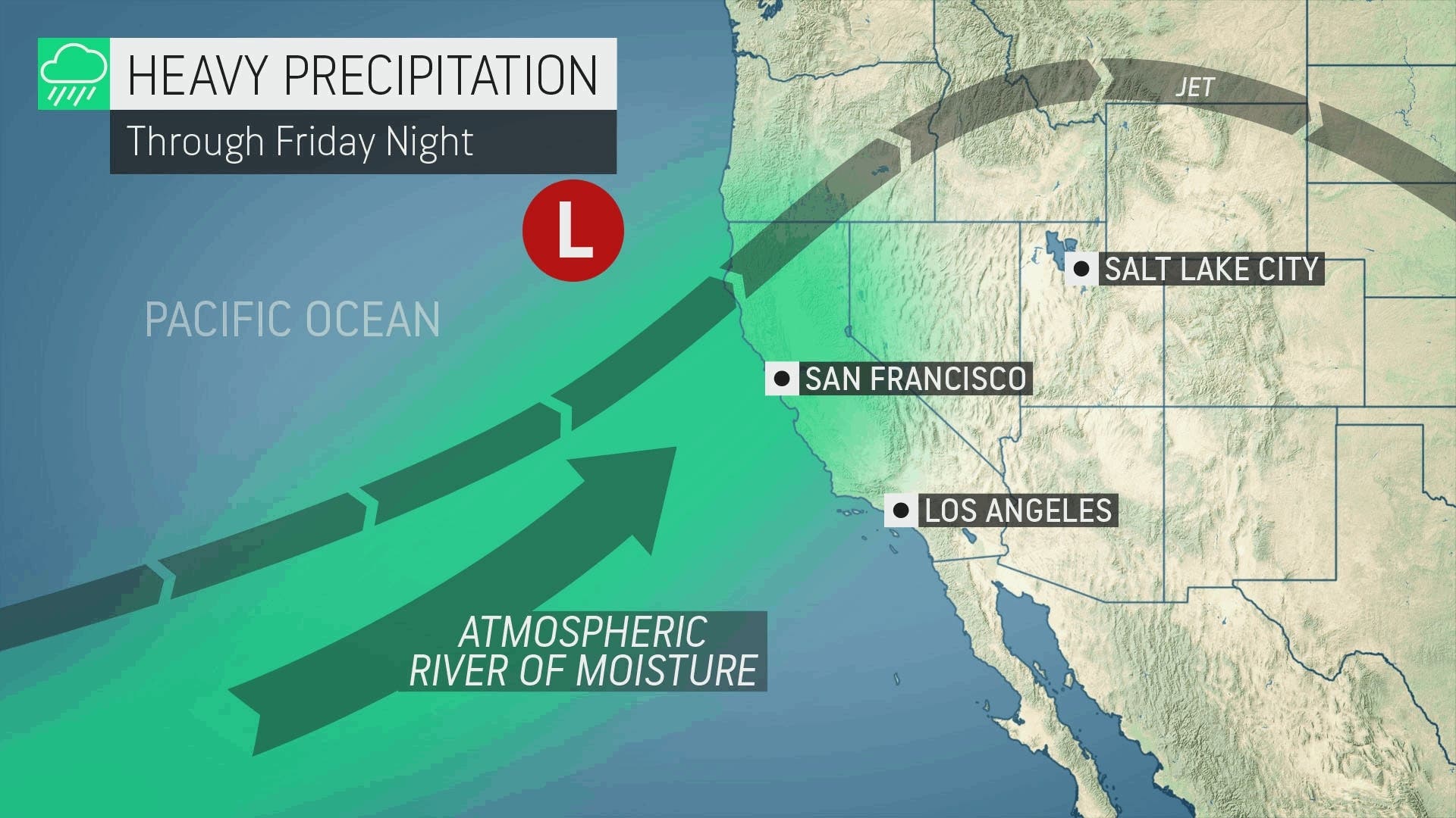
BAY AREA, CA — A severe storm labeled an atmospheric river moved ashore Thursday, prompting evacuation warnings, a flood watch, a wind advisory, road closures, ski resort closures and other impacts as most of Northern California deals with the storm.
Five people were injured in a multi-vehicle crash that included a bus in Walnut Creek. The fire department spokesperson tweeted, "Cause appears vehicle exiting highway too fast for weather. Slow down and arrive alive."
Caltrans closed portions of multiple roads in Napa and Sonoma counties Thursday evening due to flooding including multiple locations on US Highway 101, a stretch of northbound state route 29, westbound state route 12, state route 121 at state route 116 where cars were stuck in water, River Road, and more. A few rock and mudslides were reported on smaller roads.
Find out what's happening in San Franciscofor free with the latest updates from Patch.
Roads were also flooded in Contra Costa and Alameda counties.
On the Peninsula, a fallen tree blocked northbound traffic on Interstate Highway 280 in San Bruno for a time Thursday evening.
Find out what's happening in San Franciscofor free with the latest updates from Patch.

The flood watch is in effect for the entire Bay Area through Sunday.
Most of the Bay Area is at slight risk of flooding, according to computer models released by the National Weather Service-Bay Area Thursday afternoon. The Santa Cruz Mountains are at moderate risk. The Monterey Peninsula down past the San Luis Obispo area face a high risk of flooding— a threat level not seen in more than a decade.
New Excessive Rainfall Outlook for tomorrow. Central Coast has been updated to high risk for flooding. Last time the Bay Area and Central Coast was in a "high risk" was 2010. #cawx pic.twitter.com/CI238KspXR
— NWS Bay Area 🌉 (@NWSBayArea) March 9, 2023
At noon on Thursday, Santa Cruz County issued an evacuation warning to people in low-lying areas including Felton Grove, Paradise Park, Soquel Village, Rio Del Mar Flats, and areas along Corralitos Creek including the College-Lake-Holohan area.
High winds were reported on the Dumbarton and Bay bridges Thursday afternoon.
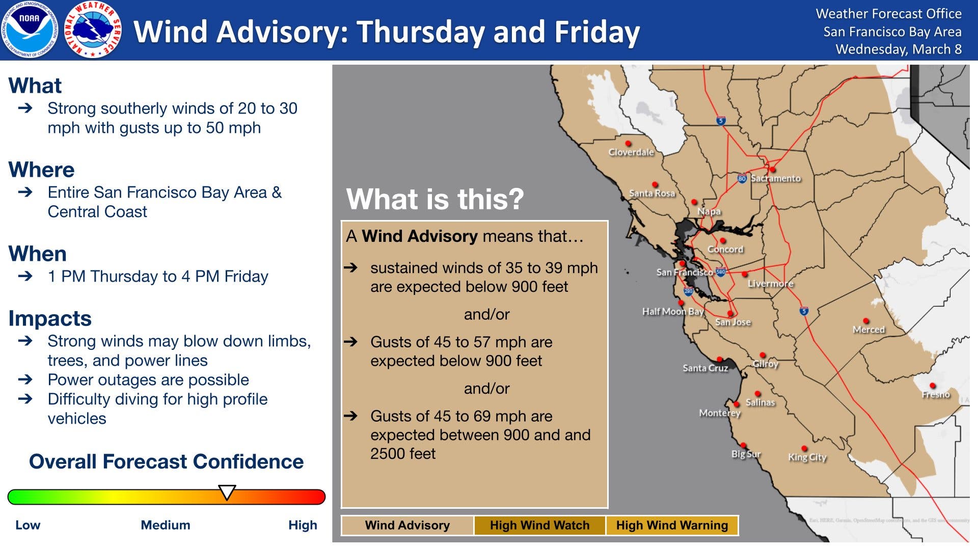
A wind advisory is also in effect for the entire Bay Area, a situation that improves the chances of downed trees and power lines. PG&E has positioned equipment and personnel in locations expected to be hit hard by the storm, most notably the Peninsula, which suffered the brunt of power outages in recent storms.
With localized flooding, downed trees and mudslides expected, San Mateo County activated its emergency operation center while Santa Clara County declared a local emergency.
In the North Bay, the City of Napa is closing flood gates to keep the Napa River out of homes and businesses, while Marin County has opened warming centers.
Like PG&E, Caltrans has positioned equipment and personnel in locations expected to be hit hard by the storm. Highway closures can be checked on this Caltrans map. Interstate 80, and Highways 50 and 88 have all closed in recent storms. The Sacramento office of the National Weather Service tweeted Thursday afternoon that travel in the mountains is discouraged through the weekend.
Several Lake Tahoe area ski resorts have already announced they will close on Friday because of the forecast for heavy snow and high winds.
Monterey County closed some of its parks including Jacks Peak, Manzanita Park, Royal Oaks Park, San Lorenzo Park and Toro Park to protect the health and safety of visitors from the heavy rain and strong winds forecasted.
To get your neighborhood forecast, enter your zip code in the Accuweather search bar. It will also show active watches and warnings from the National Weather Service.
Get more local news delivered straight to your inbox. Sign up for free Patch newsletters and alerts.