Weather
Anne Arundel Braces For Snow, Annapolis Wants Cars Off Streets
Another snowstorm could hit Anne Arundel on Thursday night. The county expects a few inches. Annapolis wants cars parked in garages.

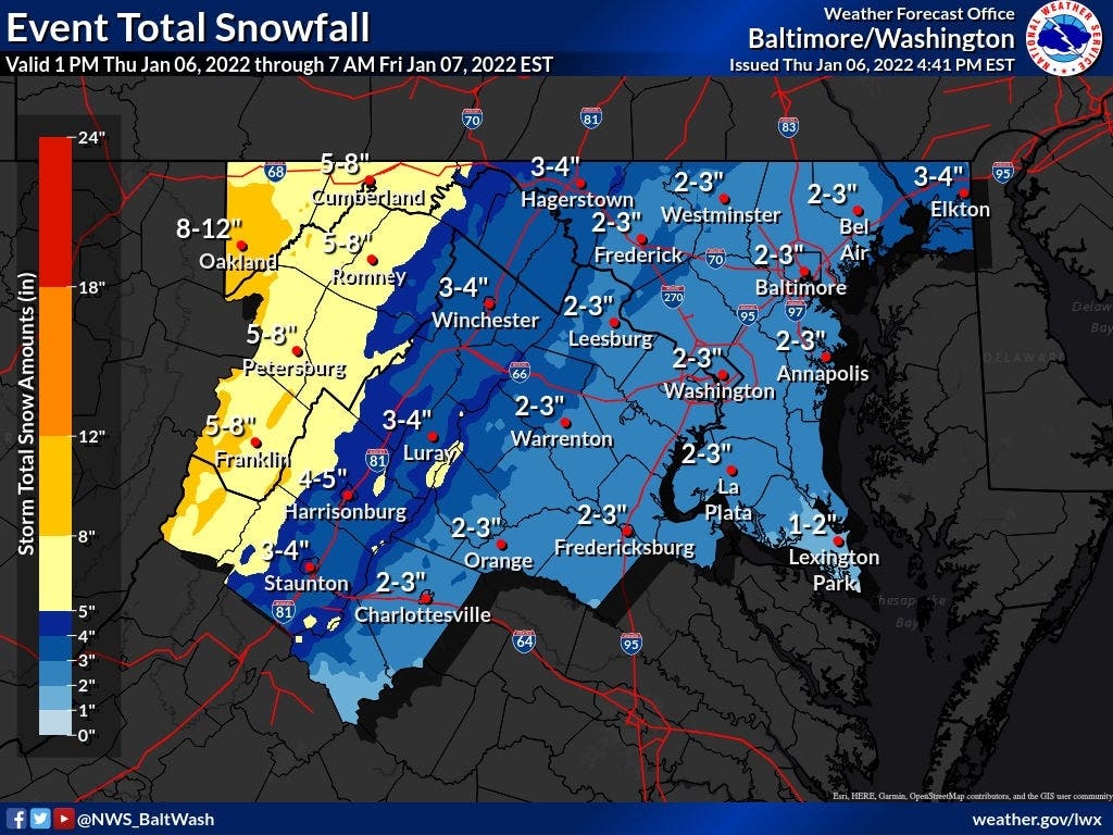
ANNE ARUNDEL COUNTY, MD — The second winter storm of the week could hit Anne Arundel Thursday night. After the county saw up to 11 inches of snow on Monday, meteorologists predicted that the county may get 2 to 3 more inches. The City of Annapolis asked residents to remove their cars from snow emergency routes to make plowing easier.
The flakes may arrive between 11 p.m. and 1 a.m. The heaviest accumulation is expected overnight when the snow could fall at 1 inch per hour. The visibility may be a half-mile or less.
Annapolis opened the Gotts Court, Knighton and Noah Hillman garages for free parking. The gates will be open, but patrons should still take a ticket.
Find out what's happening in Annapolisfor free with the latest updates from Patch.
"Parked cars are one of the biggest challenges for snow crews," Annapolis spokesperson Mitchelle Stephenson said in a press release. "Please park your cars in driveways and off public streets so plows can clear as much snow as possible."
Annapolis declared a phase one snow emergency Thursday evening. The city's plowing plan is posted at this link. More information on its transit, parks and warming centers is available here.
Find out what's happening in Annapolisfor free with the latest updates from Patch.
The storm did not have many effects on Anne Arundel County transit as of 8:45 p.m. Thursday. All dialysis, medical and Call N Ride transportation will continue. Every fixed route will run as scheduled, weather permitting. There will be no senior center transit.
Gov. Larry Hogan said the state's roads are pretreated and ready to go.
“As we did earlier this week, we have mobilized our statewide operations center in preparation for this storm, which could have a significant impact on tomorrow morning’s commute,” Hogan said in a press release. “We ask Marylanders to avoid travel tonight and tomorrow morning if possible, especially with the possibility of wind gusts that could take down trees and wires. Keeping the roads free of heavy traffic gives the crews and first responders room to do their jobs.”
The governor also made these announcements:
- Multiple state agencies, including the Maryland Department of Emergency Management (MDEM), Maryland Department of Transportation, and the Maryland State Police, are making preparations and coordinating with local jurisdictions.
- State Highway Administration (SHA) facilities are fully staffed, heavy duty tows will be staged in all regions by 7:00 pm., and tree contractors will be staged as well. SHA activity can be tracked here. All Maryland Transportation Authority (MDTA) facilities will stay fully staffed for the duration of the event and adjust resources as necessary.
- At this time, the Maryland Transit Administration (MTA) anticipates minimal impacts to service. Bus diversions will be implemented on an as-needed basis throughout tonight and into the morning.
- At BWI Marshall Airport, winter weather crews are on alert and prepared to respond. Passengers are encouraged to arrive at least two hours prior to the scheduled departure time and check flight schedules prior to leaving home.
Marylanders can follow emergency operations by:
- Visiting md511.org for traffic incident updates
- Texting ‘MdReady’—or 'MdListo' for Spanish texts—to 211MD1 to receive emergency alerts
- Visiting mdem.maryland.gov for information on storm preparedness and disaster supply kits
The National Weather Service issued a winter weather advisory for the DMV. Advisories are the least urgent weather announcement. Watches are more pressing, and warnings are the most serious.
This bulletin covers the Baltimore metropolitan area, central Maryland and the southern portion of the state. The District of Columbia and parts of northern Virginia are also included. The alert will last from 9 p.m. Thursday until 7 a.m. Friday.
"Plan on slippery road conditions," the National Weather Service said. "Slow down and use caution while traveling. When venturing outside, watch your first few steps taken on steps, sidewalks, and driveways, which could be icy and slippery, increasing your risk of a fall and injury."
The full National Weather Service announcement is available here. The expected snow arrival time is posted below.
.png)
RELATED:
- MD Snow Forecast: Weather Advisory Expanded, Friday Commute Alert
- Anne Arundel County Weather: More Snow Possible Later This Week
- Couple, Trucker Carry 300 Food Packages To Stranded I-95 Drivers
- Anne Arundel Co. Public Schools Makes Weather Decision For Jan. 5
- Anne Arundel County Snow Photos: 20 Gorgeous Pictures From Jan. 3
- Winter Storm Hits Maryland Closing Schools, Shot Clinics: Photos
- Anne Arundel Co. Public Schools Make Weather Decision For Jan. 4
- Snow Totals In Anne Arundel: South County Records 11 Inches
- Snow Pics: Send Anne Arundel Patch Your Winter Wonderland Photos
- Snow Cancels Some COVID-19 Tests, Vaccine Clinics In Anne Arundel
- Anne Arundel Co. Public Schools Make Weather Decision For Jan. 3
- Snow Emergency Declared In Annapolis, Cars Off Snow Routes
- MD Weather: Winter Weather Alerts Posted Across Maryland
Have a story idea? Please contact me at jacob.baumgart@patch.com with any pitches, tips or questions. Follow me on Twitter @JacobBaumgart and on Facebook @JacobBaumgartJournalist to stay up-to-date with the latest Anne Arundel County news.
Get more local news delivered straight to your inbox. Sign up for free Patch newsletters and alerts.