Weather
Snow, Sleet Could Snarl Friday Commute: Winter Weather Advisory
The National Weather Service has posted winter weather advisories for much of Maryland due to snow and sleet in the forecast.


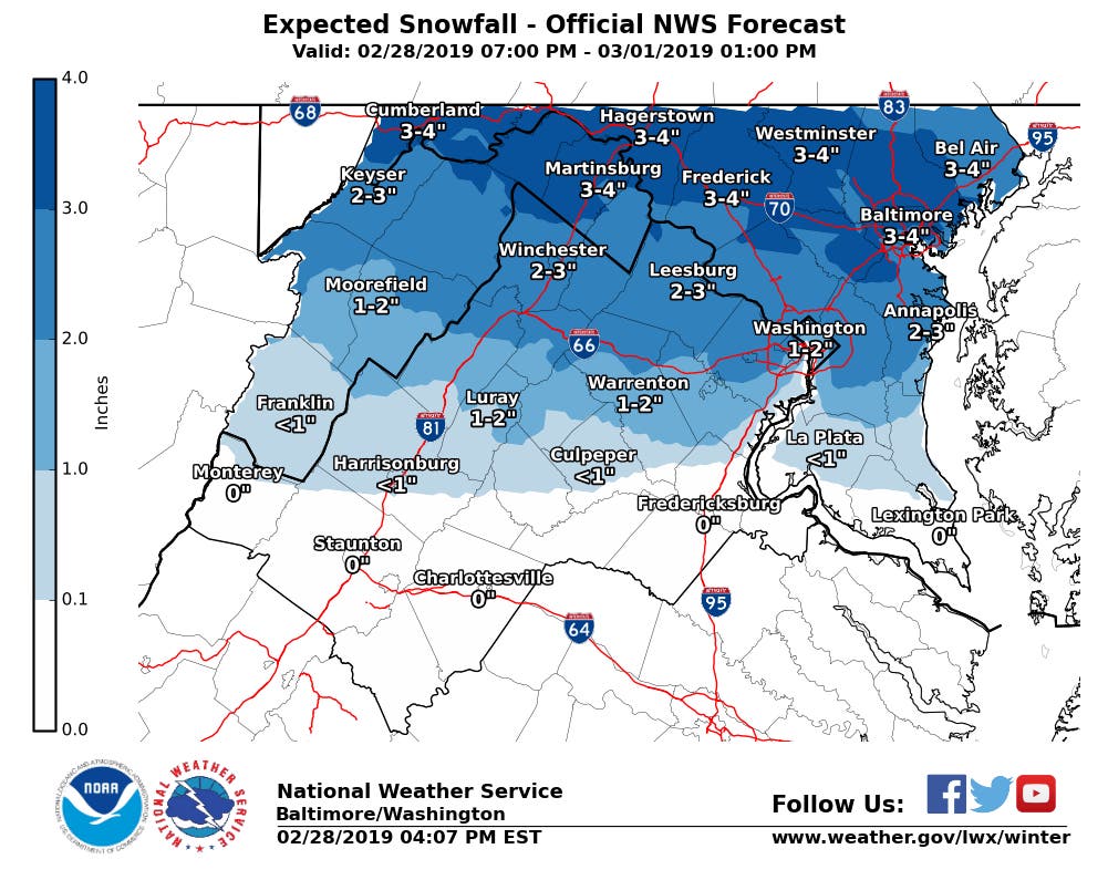
MARYLAND — The Friday morning commute could be a messy one, with up to 5 inches of snow in the forecast. Initially, the National Weather Service projected up to 4 inches of snow, but Thursday night, estimates increased for parts of Maryland.
"The highest snowfall totals are most likely near and north of Interstates 70 and 68," according to the National Weather Service.
Winter weather advisories have been issued for the Baltimore-Washington region and the Eastern Shore. The National Weather Service, which posted the advisories, cautioned people to be mindful of slippery roads, sidewalks and driveways.
Find out what's happening in Perryvillefor free with the latest updates from Patch.
"If you plan on commuting Friday morning, be aware of the potential for travel disruptions," the National Weather Service said in a special weather statement. "Plan ahead by allowing for extra travel time, and consider using public transportation and telework options."
Some school districts and campuses have altered their schedules due to the forecast.
Find out what's happening in Perryvillefor free with the latest updates from Patch.
- Aberdeen Proving Ground
- Anne Arundel County Public Schools
- Baltimore City Public Schools
- Baltimore County Public Schools
- Carroll County Public Schools
- Cecil County Public Schools
- Frederick County Public Schools
- Harford County Public Schools
- Howard County Public School System
- Prince George's County Public Schools
- Queen Anne's County Public Schools
- Towson University
- U.S. Naval Academy
Snow Estimates By Region
Baltimore City as well as Allegany, Anne Arundel, Baltimore, Calvert, Caroline, Cecil, Charles, Frederick, Howard, Harford, Kent, Montgomery, Prince George's, Queen Anne's, Talbot and Washington counties are under winter weather advisories.
The winter weather advisory for the Baltimore-Washington area is in effect from 10 p.m. on Thursday, Feb. 28, to 10 a.m. on Friday, March 1.
Snow will begin overnight and taper off after sunrise on Friday, March 1, according to the National Weather Service. Snow will mix with sleet early Friday morning, forecasters stated.
There will be 2 to 5 inches of snow in central, northern and western Maryland, according to the advisory, which timed out the precipitation Friday in these areas as follows:
- 1–3 a.m.: Snow and sleet
- 2–6 a.m.: Moderate to heavy snow
- Until 1 p.m.: Snow and sleet
- After 1 p.m.: Rain
In Prince George's County and southern Maryland, the advisory calls for 1 to 3 inches of snow as well as some sleet, according to this schedule:
- 1–3 a.m.: Snow and sleet
- 2–6 a.m.: Moderate to heavy snow
- 9–11 a.m.: Sleet and rain
- Afternoon: Rain
The Eastern Shore — including Caroline, Cecil, Kent, Queen Anne's and Talbot counties — could see 1 to 3 inches of snow accumulate during its winter weather advisory period, which is 1 to 10 a.m. Snow will fall overnight, from west to east, continuing through Friday morning, according to the advisory. Sleet and freezing rain will join the mix around daybreak, before light rain showers taper off late Friday morning, weather officials advise.
Stay up to date on the latest. Get news alerts from Maryland Patches.
Friday is not the only time there will be snow in the near future.
"There is another slight winter storm threat Sunday night into Monday morning, mainly west of Interstate 95," the National Weather Service said in a hazardous weather outlook for the region. "If the threat materializes, travel disruptions may result."
Here is the forecast for the Baltimore-Washington region from the National Weather Service:
Thursday: Mostly sunny, with a high near 42 and low of 28. Wind gusts as high as 20 mph.
Friday: Snow, mainly from 2 to 11 a.m. Then there will be a mix of snow, rain and sleet from 11 a.m. to 2 p.m., followed by a chance of rain from 2 to 8 p.m. Chance of precipitation is 90%. New snow accumulation of 1 to 3 inches possible. High of 39 and low of 32.
Saturday: A chance of rain before 1 p.m. High near 47 and low of 31. Chance of precipitation is 40%.
Sunday: A chance of rain and snow from 8 a.m. to 2 p.m., rain likely before 8 p.m., then rain and snow showers. Mostly cloudy, with a high near 43 and low of 29. Chance of precipitation is 70%.
Monday: Rain and snow showers likely before 8 a.m. High near 37 and low around 16. Chance of precipitation is 60%.
Tuesday: Mostly sunny, with a high near 31 and low of 14.
Graphic above showing snowfall projections courtesy of the National Weather Service.
Get more local news delivered straight to your inbox. Sign up for free Patch newsletters and alerts.