Weather
'Please begin preparing now' - NWS Issues Advisories For The HV
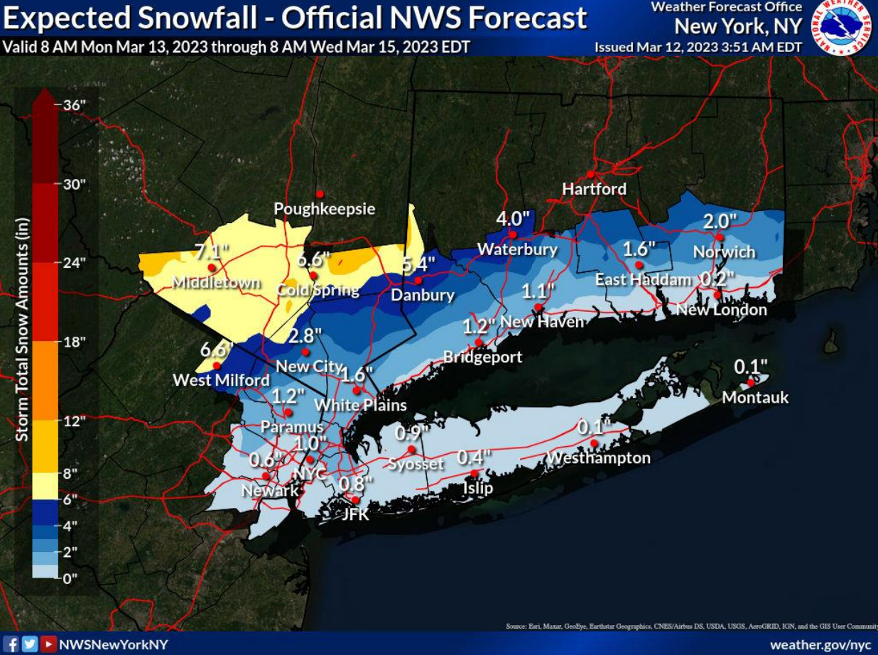
A nor-easter will bring up to 2 feet of snow in Ulster County, coastal flooding in southern Westchester, and strong winds across the region.


UPDATES Monday:
- Heavy Rain, Wet Snow, Gusty Winds: Nor'easter Hits The HV
- HV Nor'easter: State Restricts Truck Traffic, Deploys Resources
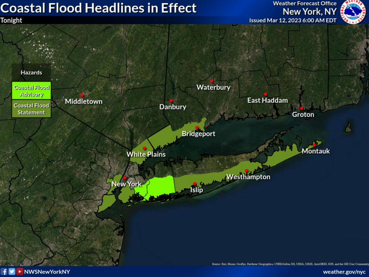
HUDSON VALLEY, NY — The National Weather Service issued winter storm watches, hazardous outlooks and a coastal flood statement Sunday about the storm expected to hit the Hudson Valley on Monday.
"This has the potential of being a long duration and high-impact snow event for eastern New York and western New England," the NWS said. "Heavy wet snow combined with strong winds will likely lead to downed trees and power outages across the area. Please begin preparing now for this upcoming winter storm event." The NWS outlooks:
Find out what's happening in Ossining-Croton-On-Hudsonfor free with the latest updates from Patch.
- Ulster County: Heavy wet snow, with snow accumulations of 1 to 2 feet possible, with higher amounts in the eastern Catskills.
- Dutchess County: Heavy wet snow, with snow accumulations of 12 to 18 inches possible. Winds could gust as high as 40 mph at times. Travel could be very difficult to impossible.
- Orange and Putnam counties: Heavy snow, with total snow accumulations of 5 to 10 inches possible. Travel could be very difficult from Monday evening through Tuesday evening.
- Rockland and northern Westchester counties: A coastal storm has the potential to bring an accumulating snowfall, mainly from Monday night into Tuesday.
- Southern Westchester: Up to one-half-foot of inundation above ground level expected in vulnerable areas near the waterfront and shoreline.
A nor-easter is bringing the moisture up the Atlantic Coast while an upper-level low front comes in from the west.
"The storm has the potential to strengthen so fast from Monday to Tuesday that it could undergo what forecasters call bombogenesis," said. Alex Sosnowski, AccuWeather senior meteorologist. "This is a term assigned to a storm that experiences a pressure drop of 0.71 of an inch of mercury (24 mb) in 24 hours or less. When the pressure drop occurs in the center of the storm, it creates a giant vacuum effect. Air then rushes in toward the center in the form of powerful winds, sometimes similar to how a hurricane develops."
Find out what's happening in Ossining-Croton-On-Hudsonfor free with the latest updates from Patch.
The combination of rain and wind could lead to a number of airline delays and possible flight cancellations from New York City to Washington, D.C., from Sunday night to Monday night. Slow travel on the roads is likely on the Interstate 95 corridor of the mid-Atlantic due to the rain and poor visibility.
"The storm’s timing from Sunday night to Monday could mean trouble for travelers returning home from weekend or spring break trips," Sosnowski said.
The precipitation could start before dawn.
"Light snow and rain showers are expected to develop during the day on Monday," the folks at Hudson Valley Weather predicted. "... any rain will transition to snow after dark on Monday. Snow will intensify overnight with snowfall rates of 1-3" per hour, this will overcome any surface temp issues with snow rapidly accumulating on all surfaces."
The strongest winds will be Tuesday into Tuesday night with NW winds 15 to 25 mph with gusts 30 to 40 mph. Some gusts along the eastern portion on Long Island may approach 45 to 50 mph, the NWS said.
Get more local news delivered straight to your inbox. Sign up for free Patch newsletters and alerts.


