Community Corner
Snow Won't Stay Away, Plans Another Visit to Long Island
Another cold front to bring another dose of snow.

Snow (of course) is back in the forecast.
It’s not looking like much, up to an inch of snow on Thursday, but after two major winter storms in a week, many Long Islanders are probably asking, “Can we sneak a sunny 50-degree day somewhere into February?”
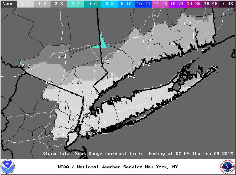
A hazardous weather outlook is in effect for all of Long Island with light snow expected to begin mainly after midnight on Thursday, according to the National Weather Service. The snow may be mixed with rain across Long Island and New York City.
Find out what's happening in Smithtownfor free with the latest updates from Patch.
- Sign up for Patch weather and breaking news alerts here
There is a chance for up to 2 inches of snow to fall on the extreme East End, the NWS says.
The NWS is also keeping an eye on a storm system that could potentially bring snow to the region next Sunday and Monday.
Find out what's happening in Smithtownfor free with the latest updates from Patch.
The NWS forecast:
- Today- Mostly cloudy, with a high near 40. Wind chill values between 20 and 30. South wind 10 to 16 mph.
- Tonight- A chance of rain and snow, mainly after 5am. Cloudy, with a low around 28. Southwest wind 7 to 10 mph. Chance of precipitation is 30%.
- Thursday- Light snow likely, mainly before 3pm. Mostly cloudy, with a temperature falling to around 24 by 5pm. Wind chill values between 10 and 20. Blustery, with a northwest wind 14 to 23 mph, with gusts as high as 37 mph. Chance of precipitation is 60%. New snow accumulation of around an inch possible.
- Thursday Night- Partly cloudy, with a low around 6. Wind chill values between -5 and zero. Northwest wind 7 to 17 mph.
- Friday- Partly sunny and cold, with a high near 20. West wind 6 to 16 mph.
More on Patch:
- Long Island Snowfall Totals
- Police: Pair Broke Into Manorville Home, Tried to Rent It Out
- Social Photos: Thousands Partake in Long Beach Polar Bear Plunge
- February 3-Suffolk Arrest Report
- Police: Drunk Driver Struck 3 Outside East Meadow Club
- Wow Houses of the Week
- Malverne Mel Predicts Longer Winter
- Port Washington Ups Food Ante with SOUPer Bowl
- Help Fire Department Help You: Clear Snow From Hydrants
Get more local news delivered straight to your inbox. Sign up for free Patch newsletters and alerts.