Home & Garden
HV Storm Update: Sunday Forecast
Get the latest updates for Putnam, Rockland and Westchester.

The snowstorm that crippled much of the East Coast will be gone (and good riddance).
The good news is that on Sunday temperatures will be in the mid 30s and skies will be mostly sunny.
The bad news is that everyone has to clean up. And there’s quite a bit to clean up. According to the National Weather Service, New City had gotten 13 inches by 2:30 p.m. Dobbs Ferry already had 10 inches dumped on it by 2 p.m. And Putnam Valley reported 6.3 inches by 1 p.m.
As airports dig out, flight cancelations and delays will reverberate nationwide for a while.
------------------------
UPDATE: Saturday, Jan. 23, 2:10 p.m.
The Metro-North and LIRR last trains inbound or outbound will be at 4 p.m. Saturday, Gov. Andrew Cuomo announced.
-----------------
UPDATE: Saturday, Jan. 23, 12:45PM
Gov. Andrew M. Cuomo has imposed a road travel ban in New York City and Long Island, effective 2:30PM. He said he wanted to give people time to get home. The original version of this report erroneously included the Hudson Valley in that ban. Patch regrets the error.
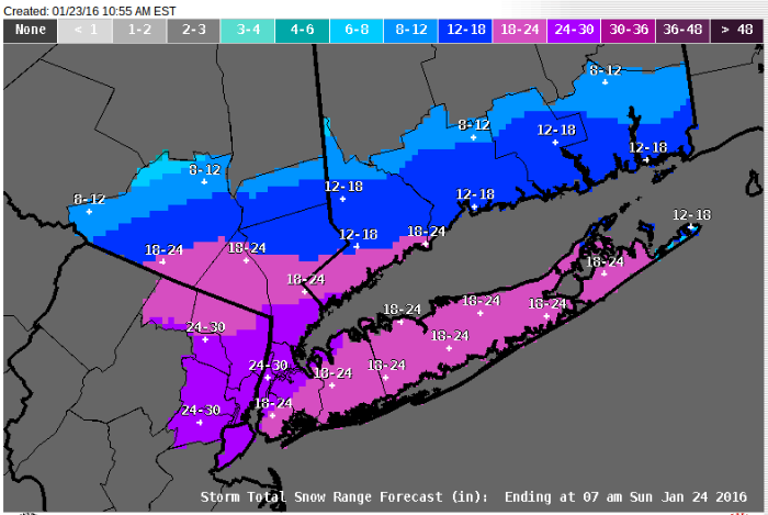
UPDATE: Saturday, Jan. 23, 10:55AM.
The National Weather service updated its map of total snow accumulation for the Hudson Valley, New York City and Long Island. See attached map.
------------------
UPDATE: Saturday, Jan. 23, 10:45AM
Westchester County suspended bus service. See Patch’s full story here.
--------------------
UPDATE: Saturday, Jan. 23, 9:40 a.m.
Rockland County suspends Transport of Rockland services. See Patch’s full story here.
---------------------
UPDATE: Saturday, Jan. 23, 8:35 a.m.
Gov. Andrew Cuomo declared a state of emergency for the Hudson Valley, Long Island and New York City. He said conditions are going to get worse and urged people to stay off the roads.
See Patch’s full story here.
-------------------
RELATED:
- Nor’Easter: Trains, Planes and Automobiles
- Jan. 23 SAT Cancellations: Scarsdale, Dobbs Ferry, New Rochelle, Ramapo, Suffern
- Coastal Flooding Possible Along Sound Shore
- Metro-North Preps for Nor’Easter
- Cuomo: State of Emergency Declared in NY
------------------
UPDATE: Saturday, Jan. 23, 7:30 a.m.
The National Weather Service updated its Blizzard Warning for Southern Westchester, predicting heavy snow with strong and potentially damaging winds, and near zero visibility at times.
Snow accumulation: 15 to 20 inches, locally higher amounts possible.
Winds: NE 30-40 mph with gusts up to 55 mph.
The NWS also updated its storm warnings for Putnam and for Rockland and northern Westchester counties.
For Rockland and northern Westchester, winds predicted to be 15-25 mph with gusts up to 35 mph. Snow accumulation 10-15 inches.
For Putnam, winds 10-20 mph with gusts up to 30 mph. Accumulation 5-10 inches, with locally higher amounts possible.
-------------------
UPDATE: Friday, Jan. 22, 11 p.m.
The National Weather Service issued a Blizzard Warning for southern Westchester.
The NWS also updated its storm warning for Rockland and northern Westchester.
-------------------
UPDATE: Friday, Jan. 22, 5:30 p.m.
The National Weather Service has issued Coastal Flood Warnings for southern Westchester for Saturday, Jan. 23, from 10 a.m. to 2 p.m. and Saturday, Jan. 23, from 9 p.m. to Sunday Jan. 24, 1 a.m.
For more see our story UPDATE: Coastal Flood Warning Issued for Sound Shore.
-------------------
UPDATE: Friday, Jan. 22, 3:38 p.m.
Several of the high schools scheduled as SAT testing centers have announced that they will be closed tomorrow: Dobbs Ferry, New Rochelle, Ramapo, Scarsdale and Suffern. Check back here for updates on additional closings.
-------------------
UPDATE: Friday, Jan. 22, 2016, 11:15 a.m.
The National Weather Service has issued a coastal flooding advisory for southern Westchester.
-------------------
But there are still conflicting local predictions for this massive storm spreading from Little Rock to Boston, bringing snow and ice, high winds and sometimes thunder and lightning.
“This storm is about as difficult a forecast as you can get… with so much conflicting data, it’s almost unbelievable,” said Bill Potter of Hudson Valley Weather. “Thanks for your patience… and as Alex would say, ‘keep calm, and weather on.’“
While long-range models minimize the storm’s affect on Putnam, Rockland and Westchester counties, short-range models show a significant snowfall, HVW said, making a lengthy video to explain why. Click to watch Hudson Valley Weather’s Detailed Forecast Discussion Video.
RELATED:
- Stay Healthy: Tips for Snow
- New Yorkers, Prepare for Nor-Easter: Cuomo
- Winter Storm Watch Issued
- Stay Safe, Warm when it’s Frigid
- Guard Against Carbon Monoxide in Cold Weather
Slate’s in-house weather reporter, Eric Holthaus, wrote Thursday that predicted snowfall paired with predicted flooding could create an “epic blizzard” that would “rival an East Coast hurricane landfall.”
Holthaus wrote:
This storm is the real deal — the meteorologist who literally wrote the textbook on Northeast snowstorms has already called it “textbook.” And for those living in some particularly vulnerable parts of the coastline, heavy snow may be the least of their worries: This storm is coming in like a landfalling hurricane.
>>SIGN UP FOR FREE NEWS ALERTS<<
BEDFORD-KATONAH • BRONXVILLE-EASTCHESTER-TUCKAHOE • CHAPPAQUA-MOUNT KISCO • HARRISON • LARCHMONT-MAMARONECK • NANUET • NEW CITY • NEW ROCHELLE • NYACK-PIERMONT • OSSINING-CROTON-ON-HUDSON • PEARL RIVER • PEEKSKILL-CORTLANDT • PELHAM • PORT CHESTER • PLEASANTVILLE-BRIARCLIFF MANOR • RIVERTOWNS • RYE • SCARSDALE • SOUTHEAST-BREWSTER • TARRYTOWN-SLEEPY HOLLOW • WHITE PLAINS • YORKTOWN-SOMERS
Get more local news delivered straight to your inbox. Sign up for free Patch newsletters and alerts.