Weather
Latest On Big Storm Heading To Pennsylvania
The strongest storm since January's 'bomb cyclone' is heading towards Pennsylvania and could bring with it heavy rain mixed with some snow.

The strongest storm since January's 'bomb cyclone' is heading towards Pennsylvania and could bring with it heavy rain mixed with some snow, as well as high winds. The storm is expected to hit the area Thursday afternoon and its impacts will be felt through Friday and even into Saturday, the NWS said.
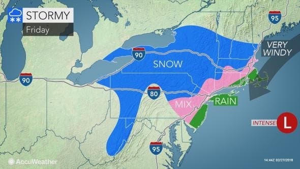
The National Weather Service has issued a Hazardous Weather Outlook for the Nor'easter storm, saying the "multifaceted" weather event could bring up to two inches of rain mixed with snow in Eastern Pennsylvania.
Flooding in areas of poor drainage and in small streams is possible, and wind gusts of up to 45 mph are predicted.
Find out what's happening in Newtownfor free with the latest updates from Patch.
Snow isn't expected to accumulate in the Philadelphia region, but areas north, including the Poconos, can expect some to stick. Area residents should be warned that there could be downed tree limbs and isolated power outages, the NWS said.
"This is likely to become the strongest storm since the bomb cyclone from early January," AccuWeather said in a Wednesday prediction. Recognizing the upcoming storm won't be as potent or result in as much snow, "it will still pack a wallop in the Northeast," forecasters from AccuWeather said in a press release.
Find out what's happening in Newtownfor free with the latest updates from Patch.
RELATED: That Time A Bomb Cyclone Hit Pennsylvania
The first part of the storm will bring "torrential" rain, and could lead to "significant disruptions" along the I-95 corridor, AccuWeather said.
It will get worse as it strengthens: colder air will be drawn in and snow will advance toward the coast on Friday. "Wet snow will probably mix near the end of the storm from Philadelphia to New York City and Boston," AccuWeather Senior Meteorologist Brett Anderson said.
Here is a map of impacts:
Here is the local forecast:
Today: Partly sunny, with a high near 60. Southwest wind around 11 mph.
Tonight: Mostly cloudy, with a low around 42. Southwest wind 5 to 8 mph becoming calm after midnight.
Thursday: Rain, mainly after 2pm. High near 56. Calm wind becoming east 5 to 8 mph in the afternoon. Chance of precipitation is 80%. New precipitation amounts between a tenth and quarter of an inch possible.
Thursday Night: Rain. Low around 40. East wind around 10 mph becoming north after midnight. Chance of precipitation is 90%. New precipitation amounts between a half and three quarters of an inch possible.
Friday: Rain. High near 44. Breezy, with a northwest wind 13 to 21 mph, with gusts as high as 36 mph. Chance of precipitation is 80%. New precipitation amounts between a quarter and half of an inch possible.
Friday Night: Rain showers before 3am, then a chance of rain and snow showers. Low around 36. Breezy. Chance of precipitation is 80%. New precipitation amounts between a tenth and quarter of an inch possible.
Saturday: A chance of rain and snow showers before 8am. Mostly cloudy, with a high near 46. Chance of precipitation is 30%.
Saturday Night: Mostly cloudy, with a low around 33.
PHOTO via Shutterstock
Get more local news delivered straight to your inbox. Sign up for free Patch newsletters and alerts.