Weather
Hail, Damaging Winds Possible As Severe Storm Watch Issued In VA
Damaging winds, heavy rain and frequent lightning are expected Friday, with another round of storms possible Saturday, forecasters said.


A severe thunderstorm watch is in effect for much of Northern Virginia on Friday as forecasters warn that storms could bring damaging winds, torrential rain and frequent lightning to the region.
The watch is in effect until 9 p.m., according to the National Weather Service, and includes several counties, including Arlington, Fairfax, Fauquier, Loudoun and Prince William. The cities of Alexandria, Fairfax, Falls Church, Manassas and Manassas Park are also included.
Scattered to numerous thunderstorms are expected Friday afternoon and evening, particularly east of the Alleghenies, NWS forecasters said.
Find out what's happening in Across Virginiafor free with the latest updates from Patch.
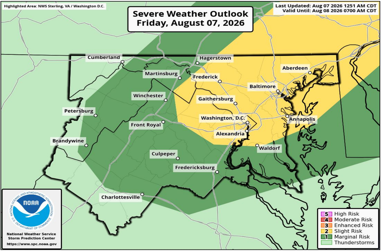
Damaging wind gusts are the main threat and could knock down trees and power lines, potentially causing outages. Locally heavy rain and frequent lightning are also possible.
Capital Weather said the watch carries the potential for a few storms with wind gusts up to 65 mph and hail up to 1 inch. Storms are most likely between 3 and 9 p.m., with the greatest chance around the Capital Beltway between 4 and 8 p.m.
Find out what's happening in Across Virginiafor free with the latest updates from Patch.
The storms also come amid another hot and humid day in the D.C. region.
Highs are expected to reach the upper 80s and low 90s, but humidity could make it feel like the upper 90s to low 100s, Capital Weather forecasters wrote.
Another round of scattered thunderstorms is possible Saturday afternoon and evening. Those storms could bring locally damaging winds, heavy rain and isolated flooding, although the National Weather Service expects less storm coverage than Friday.
Detailed Northern Virginia Forecast
Friday Afternoon: Showers and thunderstorms likely, mainly after 3pm. Some of the storms could be severe. Partly sunny, with a high near 91. Southwest wind around 8 mph. Chance of precipitation is 70%. New rainfall amounts of less than a tenth of an inch, except higher amounts possible in thunderstorms.
Friday Night: Showers and thunderstorms likely, mainly before 8pm. Some of the storms could be severe. Mostly cloudy, with a low around 70. Light southwest wind. Chance of precipitation is 60%. New precipitation amounts of less than a tenth of an inch, except higher amounts possible in thunderstorms.
Saturday: A chance of showers and thunderstorms before 3pm, then showers likely and possibly a thunderstorm between 3pm and 4pm, then a chance of showers and thunderstorms after 4pm. Mostly sunny, with a high near 91. Calm wind becoming southwest 5 to 7 mph in the afternoon. Chance of precipitation is 60%. New rainfall amounts between a tenth and quarter of an inch, except higher amounts possible in thunderstorms.
Saturday Night: A chance of showers and thunderstorms before 8pm. Partly cloudy, with a low around 72. Southwest wind around 5 mph becoming calm in the evening. Chance of precipitation is 30%.
Sunday: Mostly sunny, with a high near 90. Calm wind becoming northwest around 6 mph in the morning.
Sunday Night: Partly cloudy, with a low around 72.
Monday: Sunny, with a high near 91.
Monday Night: A slight chance of showers and thunderstorms before 2am. Partly cloudy, with a low around 73. Chance of precipitation is 20%.
Tuesday: A slight chance of showers and thunderstorms after 2pm. Mostly sunny, with a high near 92. Chance of precipitation is 20%.
Get more local news delivered straight to your inbox. Sign up for free Patch newsletters and alerts.